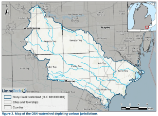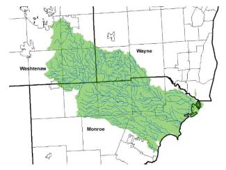
Figure 1: The Ottawa-Stony (North) watershed begins in Washtenaw County and flows through Wayne and Monroe counties before emptying into the Western Lake Erie Basin.
The Ottawa-Stony North (OSN) is the northern half of the Ottawa-Stony Watershed. The Ottawa-Stony is actually cut in half thanks to the River Raisin. While its southern boundaries contain most of Monroe County and extends into Ohio, its northern border includes Monroe, Washtenaw, and Wayne County (Figure 1).
In 2020, the WCCD applied for a grant to develop the first state-approved watershed management plan for the OSN. In 2021, WCCD was awarded the grant to undertake the project in partnership with the Monroe Conservation District and local governments. This project was funded in part through Michigan Department of Environment, Great Lakes, and Energy’s (EGLE) Nonpoint Source Program by the United States Environmental Protection Agency under federal assistance agreement C600E727-21.
In November of 2024, the Ottawa-Stony North Watershed Management Plan was approved by Michigan’s Environment, Great Lakes, and Energy (EGLE) and the Environmental Protection Agency (EPA). This plan has been four years in the making, and we are happy to share it with all of you!
Read the Ottawa-Stony North Watershed Management Plan (PDF)
In 2025, the WCCD was awarded another grant for a project that will implement portions of the plan. This Ottawa-Stony North Education & Demonstration program will run from 2026-2028. This funding is provided in part through EGLE’s Nonpoint Source Program by the United States Environmental Protection Agency (USEPA) under federal assistance agreement C997547425 and the Renew Michigan Fund.
This multi-year watershed implementation grant will focus on agricultural best management practices, septic system education, rain garden education, and stakeholder coordination in the Ottawa-Stony North watershed.
Key partners on this project include: Monroe Conservation District, Washtenaw County Water Resources Office, Washtenaw County Environmental Health Division, Sustainable Ag Solutions, Calder Dairy, and local townships.